| |
ANENHÜTTE

We returned to the Lötschental on 12 October 2003,
where we had walked up to
Chrindellun
earlier in the year from the same trailhead.
Unlike our last visit, there was now snow on the ground and
the larch were turning gold. We opted to walk up the valley
toward the foot of Langgletscher and Anenhütte.
|
|
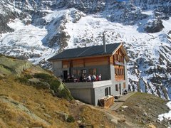
Anenhütte perched high on a rock [308 Kb]
|
From the trailhead, elevation 1780 meters, it's an easy stroll up
the valley toward the foot of the Langgletscher.
The trail parallels the Lonza River as it meanders through open larch
forests.
This was a beautiful crisp autumn day, and the fresh snow on the ground
contrasted nicely with the larch trees and the clear sky.
Part way up the valley, the trail enters the
Jungfrau-Aletsch-Bietschhorn UNESCO World Heritage site; the source
of the Grosser Aletschgletscher is just beyond the Lötschenlücke,
which is the source of the Langgletscher.
A trail junction is reached at about three kilometers, elevation 2000 meters.
Continuing straight ahead leads to a close up encounter with the snout of the Langgletscher
while the trail to the north leads up to Anenhütte. Fiona went for
the glacier (less elevation gain...) while I went for Anenhütte
(more views). The walk up to Anenhütte from the valley bottom is
not difficult, although just below the hut there was some deep snow on
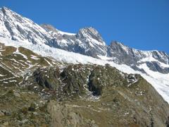
the trail which had fallen earlier in the week. The views from Anenhütte
at 2355 meters back down the valley are pleasant. The seracs on the
Anungletscher just behind Anenhütte are also impressive.
|
|
Anenhütte [491 Kb]
|

|
|
Lötschental from Anenhütte [212 Kb]
|
Other stuff:
Other pictures
|


