| |
MOUNT MCLoughlin

|
|
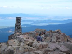
Summit of Mount McLoughlin [204 Kb]
|
Mount McLoughlin, a 2894 meter volcanic cone in the Sky Lakes Wilderness,
is the highest point in southern Oregon.
Starting at an elevation of 1700 meters, the lower portion of the nine kilometer summit trail
trail is dusty but otherwise in excellent condition; a short portion of the lower trail
passes along the Pacific Crest Trail.
The tree vegetation in the lower elevations is composed largely of Shasta red fir and
mountain hemlock, along with a few lodgepole pine and other trees. What little
undergrowth exists is composed mostly of manzanita.
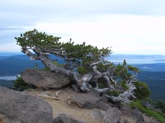
Whitebark pine, stunted from the harsh conditions, is the only tree found
on the higher slopes.
|
|
Whitebark pine [262 Kb]
|
The formal trail ends near the treeline at about 2500 meters, but the rest of
the summit climb is a fairly simple scramble over large boulders and scree.
The summit provides a 360° panorama of the surrounding area, but Mt. Shasta
and a few of the nearby lakes were the only things I recognized.
The remains of 1929 era fire lookout sit atop the summit.
We climbed Mount McLoughlin on a comfortable and bug-free day on
September 3, 2005 while visiting nearby Klamath Falls for a family wedding.
Other stuff:
Other pictures
|