| |
VIERGE de LEAZ

The weather on 7 September 2003 looked threatening, so we decided to
try a local walk along the Rhône rather than heading for the alps
as usual. We drove the short 18 kilometers to Fort de l'Ecluse,
first established in the 13th century at the strategic
point where the Rhône cuts its way through the Jura Mountains.
Rather than tour the fort, we headed off in the opposite direction
toward Vierge de Leaz, a rocky promontory with a fine view of the
surrounding area.
|
|
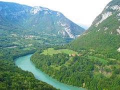
Rhône River [273 Kb]
|
The route first follows a little used road,
then enters the forest on a trail as it draws closer to the
banks of the Rhône. With few trail signs, finding the correct
route was far from obvious.
The last part of the walk up to Vierge de Leaz involves a moderate
climb, but the views from the top are quite rewarding
with sweeping vistas in both directions along the Rhône.
Fort de l'Ecluse can be seen clinging to the rock face above the river.
We descended from Vierge de Leaz on an alternate trail, intercepting our
earlier route near the Rhône for the walk back to the parking area.
Shortly after arriving back at our apartment building in
St. Genis,
the skies opened up with an impressive lightning storm and downpour.
Other stuff:
Other pictures
|