| |
GWILLIM LAKES

There are only two easy access points to the Valhalla Provincial
Park in the Selkirk Range of British Columbia. Both of these
access the park from its southern boundary via long logging
road travel up the Little Slocan River, continuing up either the
Bannock Burn road or the Hoder Creek road. The former leads to
the Gimli Ridge trailhead while the latter leads to the Gwillim Lakes
trailhead. We took the trail to Gwillim Lakes in August 1997.
|
|
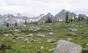
View from Gwillim Lakes [289 Kb]
|
From the trailhead at 1615 m, the trail ascends a lightly forested
ridge before curving to the north to ascend a boulder slide.
A campsite at Drinnon Lake,
elevation 1950 m, is reached about two km from the trailhead.
The trail
continues to climb to another small lake at Drinnon Pass, elevation
2225 m, about 3.5 km from the trailhead.
There is another campsite
here, where we enjoyed a lunch break and the great views.

|
|
Lower Gwillim Lake [182 Kb]
|
From Drinnon Pass, the trail now descends about 300 m to a
forested basin with another small lake and Gwillim Creek.
The esthetic climb back out of the basin
more that makes up for the added effort of the elevation just lost.
The trail hugs a rock rib on a steep rock face as it
approaches the Gwillim Lakes basin. Views across the small
lake basin to Gregorio Peak are impressive. The first
Gwillim Lake, elevation 2170 m, is reached about six km
from the trailhead. There is a fine campsite at the lakes,
with fixed tentpads and an iron bear-proof food cache.
Lucifer Peak lies to the northeast across the lakes. Views to
the high peaks south and east of the lake basin are
magnificent.
Given adequate time, opportunities for further exploration
above the Gwillim Lakes basin are plentiful. This
would be a fine place to return for a multi-day adventure.

|
|
Hiding from nonexistent mosquitoes [254 Kb]
|

|
|
Descending from Gwillim Lake Basin [558 Kb]
|
Other stuff:
Other pictures
|


