| |
ICELINE

|
|
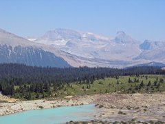
Looking across to Mt's Daly and Niles [300 Kb]
|
The Iceline trail, along with the trails of the Lake O'Hara area, is one of the
premier hikes in Yoho National Park. Unlike the Lake O'Hara area however,
The Iceline is easy to access from its trail head at the Takakkaw Falls
picnic area. The Iceline is one of those classic hikes where there is
no real destination, most of the trail traversing a very aesthetic
landscape surrounded by magnificent views. Being a loop trail, there
is no retracing of steps, so the scenery is always new from beginning
to end.
We hiked this trail first in August 1999, and again on 20 August 2003.

|
|
Alpine tarn below glacier [517 Kb]
|
From the 1510 meter trail head behind the Whiskey Jack Hostel
near the Takakkaw Falls picnic area, the trail climbs on
a good trail through sub alpine forest towards
Yoho Pass.
At about two kilometers, 1645 meter elevation, the Iceline trail goes right
at a junction; straight ahead leads to Yoho Pass.
The trail continues to climb through thinning forest, breaking
into the open at about 3.5 km, elevation 1860 meters, near another
junction leading back to Yoho Pass. At this point about half the
elevation gain has already been achieved. The remaining elevation to
be gained is done so very gradually as the trail traverses the scree filled
terraces between the glaciers and timberline.

|
|
Retreating glacier [367 Kb]
|
Once above timberline, the next couple of hours are spent in a magnificent
setting, walking along a trail cut through a landscape only recently left clear
by retreating glaciers on the northeast face of the President Range.
Numerous small glaciers and alpine tarns still remain alongside
the trail, and views across the Yoho Valley to Takakkaw Falls and the crest of
the Rockies are stunning. The high point of the trail is about 2200 meters,
near a junction with another trail that goes down to Celeste Lake.
At about 10 km, the trail starts its descent into the forest again to the
Little Yoho Valley, reaching the ACC Stanley Mitchell Hut at about 12 km,
which may be booked for overnight stays.
From here, it is another three km down to Laughing Falls
where the Little Yoho River flows into the Yoho River. The trail now
follows the Yoho River back to the Takakkaw Falls trailhead, for a
total trail loop distance of about 22 km.
Although there are some interesting sections when close to the river,
much of the last several kilometers to the trailhead
is rather dull when compared to the traverse up above.
Other stuff:
Panoramic pictures
Other pictures
|