| |
YELLOW ASTER BUTTE

|
|
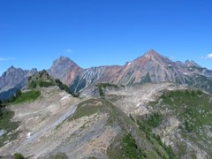
The Border Peaks and Mount Larrabee [322 Kb]
|
Of all the hiking areas along the North Fork Nooksack River on the north side of Mount Baker,
Yellow Aster Meadows ranks as our favourite and is the destination we've visited most often.
Up until recently, access to Yellow Aster Butte and Meadows has been via the
Keep Cool Trail,
an old miners' trail put in to access gold prospecting in the meadows.
With the Keep Cool Trail now closed, access to the area is via a new trail
which breaks off from the Gold Run Pass trail about 200 meters below the pass.

|
|
[442 Kb]
|
The new trail is much more aesthetic than the Keep Cool Trail, contouring through meadows
around the southern flanks of Yellow Aster Butte before ascending to a false summit
about 15 meters lower than the true summit, which is located about 500 meters
further to the north. Views from Yellow Aster Butte are magnificant in all direction,
with a good mix of jagged and icy peaks along with alpine meadows.
Access to the Yellow Aster Meadows and lakes involves a descent of about
80 meters from the Yellow Aster Butte trail, just before the
final steep accent to the false summit.
We've also approached the Yellow Aster area via
Excelsior Pass
and the High Divide trail, coupled with with an easy off-trail route linking
Welcome Pass with the meadows.
Some of the pictures shown here were taken during a hike on July 31, 2005, when the
alpine flowers were in full bloom. Other pictures we taken at the prime of fall
colours on September 30, 2010.
Other stuff:
Panoramic pictures
Other pictures
|