| |
HALEAKALĀ

|
|
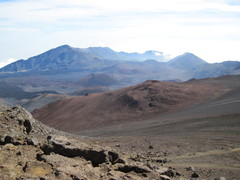
Haleakalā Crater [341 Kb]
|
The Haleakalā volcano, dormant since 1490, forms the central core of East Maui, with a summit
elevation of 3055 meters. The summit area is dominated by the huge Haleakalā crater,
measuring about 35 sq km in area and 800 meters deep. The summit, crater, and the southeast
portion of the volcano extending down to the ocean form Haleakalā National Park,
although the latter section of the park is closed to entry to protect its endangered ecosystem.
Possibly the best option for a long day
hike in the crater is to decend from the Sliding Sands trailhead near the summit,
traverse the crater floor northward towards Ko'olau Gap, and then return to the crater
rim 19 km later at the Halemau'u trailhead, which lies about 530 meters lower than the starting point.
The winter weather conditions in the crater can be cold and wet, so warm clothing not unlike
that used for summer alpine hikes in the Pacific Northwest is recommended.
|
|
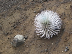
Haleakalā Silversword [622 Kb]
|
Having successfully dried out my sox after the previous day's hike on
Waihe'e Ridge,
I got a reasonably early start on the 90 minute drive from my hotel at Kihei to the
crater, left my car at the Halemau'u trailhead, then hitched a ride to the summit with my
daughter who would be doing a shorter excursion with her husband and friends.
We walked together for the first three km, then parted company at the trail juction
to the Ka Lu'u o ka 'Ō'ō cinder cone. The steep descent from
the crater rim ends after 6 km at a junction, where I took the northward trail which
meanders across the crater floor past Ka Moa o Pele and Haleāli'i before finally
joining the Halemau'u Trail.

|
|
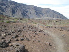
Haleāli'i and Pu'u Naue [370 Kb]
|
The walk across the crater floor was fascinating, with ever-changing scenes of colourful lava,
cinder cones, and the weird and rare Haleakalā Silversword which grows nowhere else
on Earth. I had the trail largely to myself on the crater floor, being passed only
by two pairs of hikers while I was stopped for lunch.
The trail along this route generally continues to lose elevation as it makes its way toward Ko'olau Gap,
reaching a low point of 2010 meters, 1.7 km past Hōlua, at the base of a rocky spine
which extends down from the crater rim. The increased vegetation here is probably due to
the moisture in the clouds which enter the crater through the windward facing Ko'olau Gap.
From this point, the Halemau'u Trail has been carved into the cliff face for its 400 meters
ascent over 4 km back to the crater rim and the Halemau'u trailhead.
I did this hike on March 3, 2011 under great weather conditions, the days previous and
following apparently socked in and wet.
|
|
Approaching Hōlua [555 Kb]
|
|
|
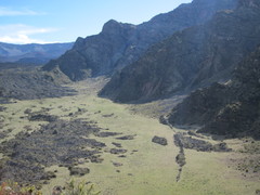
View north into the crater [422 Kb]
|
Other stuff:
Other pictures
|